Mountains, trees and weather
What was here before the farms?
The Sacramento–San Joaquin Delta. A true how-it-works story for kids 5–12.
The Sacramento–San Joaquin River Delta story, read aloud
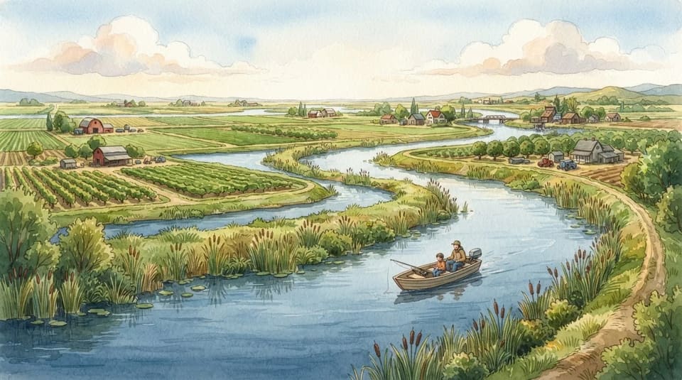
Far away in California, two big rivers meet in a place called the Delta. The Delta is a giant maze of rivers and islands, all tangled together. So what was there before the farms? Meet the tules. Tules are tall, grassy plants, taller than a grown-up! Long ago, tules covered the islands like a big green carpet.
Every day the water rose and fell around them, like a bathtub filling and draining. Then people came who wanted farms. They built long walls of dirt, called levees, to keep the river out. Then they pumped the water off the land. But the soft, spongy ground dried out and sank way down! Can you guess how low?
Lots of fields are now lower than the river beside them. The river peeks over the wall like a nosy neighbor: hello, carrots! Today the levees still hold the water back from the farms. And tules still grow along the edges, waving at the boats.
Quiz the back seat
What do the dirt walls called levees do?
Show the answer
Keep the river out of the fields. They keep the river out! Without them, lots of fields would be underwater.
Sacramento–San Joaquin River Delta facts for kids
- The Delta forms where the Sacramento and San Joaquin rivers meet, at the western edge of the Central Valley.
- It was once a tidal marsh of tule reeds; levees and draining made farms, and the peat soil sank below the water level.
- The Delta covers about 1,100 square miles of land and water.
The Sacramento–San Joaquin River Delta story, read aloud
Far south of Canada, in California, two big rivers called the Sacramento and the San Joaquin meet and tangle together. That tangle is the Delta, a maze of islands and winding water covering about eleven hundred square miles. So what was there before the farms? Let's follow one handful of river mud to find out. When the ice age ended, the sea level rose. River water carrying mud rushed toward the ocean, but it had to squeeze through one skinny gap called the Carquinez Strait, the only way out of the whole Central Valley.
Because the gap was so narrow, the mud piled up like cars jammed at a one-lane bridge. Our handful of mud settled into an island, and tall reeds called tules, said TOO-lees, grew on top. Here's the surprise: when tules died in that soggy water, they didn't rot away. They squished into a spongy soil called peat, for thousands of years. Think of it as very old, very flattened salad. Then people came, built walls of dirt called levees around the marsh, drained it, and planted farms on the peat soil.
But draining the peat made the islands sink. Here's a guess for the car: standing in one of those fields, would you look up or down at a passing boat? Up! Many Delta farms now sit lower than the rivers right beside them. Only the levees hold the water back, guarding fields that grew from a marsh of reeds.
Quiz the back seat
What is the only way out of the Central Valley that jammed up the river mud?
Show the answer
The Carquinez Strait. The Carquinez Strait! It's so narrow that river mud piled up behind it and formed the Delta's islands.
Sacramento–San Joaquin River Delta facts for kids
- The Delta covers about 1,100 square miles of land and water.
- River sediment piled up behind the narrow Carquinez Strait, the only outlet from the Central Valley.
- Draining the peat for farming made many Delta islands sink, and many farms now sit lower than the adjacent rivers.
Questions kids ask about Sacramento–San Joaquin River Delta
What was the Sacramento–San Joaquin Delta before the farms?
It was wet, spongy land covered with tall reeds called tules, with water rising and falling around them every day.
What is a levee?
A levee is a long wall of dirt built to keep a river from flooding the land beside it.
Why are some Delta fields lower than the rivers?
After the water was pumped out, the soft, spongy ground dried and sank.
For grown-ups
Written with AI from public sources, then checked claim by claim against the sources below before it was published; stories that don't pass stay off the app and this site. Narration is pre-recorded, and nothing you do on this page is tied to your kids.
Sources
- en.wikipedia.org/wiki/Sacramento%E2%80%93San_Joaquin_River_Delta
- nature.org/en-us/get-involved/how-to-help/places-we-protect/delta
- sacvalleycnps.org/freshwater-marsh
- pubs.usgs.gov/circ/circ1182/pdf/11Delta.pdf
- nrcs.usda.gov/plantmaterials/lapmcpg15000.pdf
- calfloranursery.com/plants/schoenoplectus-scirpus-acutus-var-occidentalis
- cawaterlibrary.net/document/levee-failures-in-the-sacramento-san-joaquin-river-delta-characteristics-and-perspectives
- portofstockton.com/wp-content/uploads/2021/04/Early_Reclamation_Abandonment_Central_Sacramento-San_Joaquin_Delta.pdf
More stories about how things work
 Inventors and firsts The Moon's Invisible Tug
Look out the window at the salty water beside our road. It looks calm, but it never sits still.
 Inventors and firsts The First Thing Scanners Bought
See all those shops we're passing? At their checkouts, a little red light reads black stripes on every box.
 Who built that? The Bridge That Grows
Out the window is the highway, with bridges and overpasses carrying our road over rivers and other roads. And every bridge has a secret…
 Houses A House That Came by Train
Look at all the houses on this street! Every house is made of lots of pieces.
Between stories: 25 road trip games for kids · Road trip bingo cards · Road trip trivia · Christmas light scavenger hunt · Christmas trivia
Town and county names: GeoNames (CC BY 4.0).